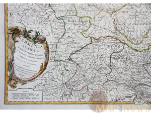
Antike Landkarte "Germania Antiqua in quator magnos populous" von 1756, aufwendig gerahmt, flächenkoloriert, sehr guter Zustand, 250 €
Germania Antiqua Antique map Germania Vaugondy 1756
Germania was inhabited by different tribes, most of them Germanic but also some Celtic, proto-Slavic, Baltic and Scythian peoples.
Taken from: Atlas Universel… Publisher : Boudet Paris
Reference: Pedley. Belle et utile, p. 175 no.247.
Engraver: Elisabeth Haussard.
Cartographer: Gilles Robert de Vaugondy (1688-1766)
Gilles Robert de Vaugondy (1688–1766), also known as Le Sieur or Monsieur Robert, and his son,
Didier Robert de Vaugondy (c.1723–1786), were leading cartographers in France during the 18th century.
http://en.wikipedia.org/wiki/Robert_de_Vaugondy
Fine original antique copper plate engraving with hand coloring.
Sheet app.: 67 x 51.5 cm. 26.5 x 20 inches.
Image app:. 59 x 47 cm. 23 x 18.5 inches.
Condition: Very good for a more than 250 year old map. Nice hand coloring. Hand line paper, center fold as published.